Paspardo rock art, because of its considerable extension, is divided into several sub-areas, each one generally characterized by subjects or carving styles that are quite unique among the other rock art sites of the Middle Valley. Although several rock art areas have been discovered and hundreds of carved surfaces are still under study by the archaeologists, only a little part of this extraordinary heritage is open to the visit and supplied with routes and touristic panels.
On the whole, there is a clear distinction between a group of sites placed near the Paspardo village (areas of Castagneto-la Bolp-In Vall, Plas-Capitello dei Due Pini, Dos Sottolaiolo) and the hundreds engraved rocks scattered along the mountainside between Paspardo and Capo di Ponte (a big area, generically named Vite-Deria).
Within the latter, the only route open to the public is Vite-‘Al de Plaha.
Virtual Tour (Dos Sottolaiolo)
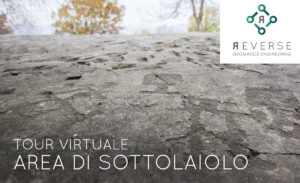
Presentation image of the Sottolaiolo Virtual Tour. Select to access the link.
Dos Sottolaiolo
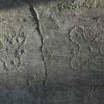
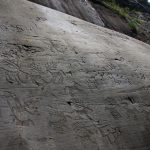
Since 1980, the “Soprintendenza Archeologica della Lombardia” (Archaeological Superintendence of Lombardy) and the “Centro Camuno di Studi Preistorici” (CCSP) carried out an impressive archaeological survey between Paspardo and Capo di Ponte, in preparation for the construction of a new road in the locality collectively known as Deria. In the spring of 1984, seven rocks were noted in a place locally known as Dos Sottolaiolo, which CCSP recorded and studied during the next few years, creating a corpus that was published by the Società Cooperativa Archeologica “Le Orme dell’Uomo” (lit., Archaeological Cooperative Society “Footsteps of Man”) in 1988. The Cooperative resumed work here in 1995, when about ten new rocks were detected.
The entrance to the area is a small terrace formed by glacier action, with a wonderful panoramic view on the Middle Valley (especially, on the mountains Pizzo Badile Camuno, to the South, and Concarena, to the West), and can be easily reached driving for a few hundred metres along the “Strada della Deria”, directly linking Paspardo and Capo di Ponte. A large parking area allows to leave the car to have a walk through the engraved rocks of the site. Today, the area is shaded by chestnut, hazel, dogwood, and wild cherry trees, but the prehistoric environment must have been very different – given that chestnut cultivation was introduced in this area by the Romans.
Among its most relevant rocks there are R1, carved with two four-petal Camunian roses and expanded-bladed axes compositions, dating back to the Late Iron Age; R2, with plenty of Iron Age warriors and some shovel figures; R4, also presenting shovels, warriors and some Historic Age crosses; R5, dominated by a large image of a warrior engraved in a peculiar local style, almost identical to the ones found in the above area of In Vall.
Castagneto, La Bolp, In Vall
 After passing over the parking area next to the playground on the Western side of Paspardo, the path goes across a thick wood of centuries-old chestnut trees. The area below the path, fittingly called Castagneto (Italian for “chestnut tree wood”), includes a dozen of carved rocks.
The only one open to visit is R1, better known as the “Rock of the Spirits”, situated inside the aforementioned playground and nearly covered by a house, built in recent times. It was studied by the CCSP as early as the 1960s. Its surface is marked by a large and apparently confused group of pecked figures, recently identified as a likely “topographic representation” of the most ancient period (Late Neolithic/Early Copper Age). As previously mentioned, the geometric composition theme is shared by the whole Paspardo area and can be found also in some of the few surfaces forming the Castagneto site, which today are mostly hidden by a thick vegetation.
The path goes on southward, crossing the area of La Bolp, where, next to the carved rocks (Iron Age warriors and Christian crosses), there is a little rest area and a noteworthy view point on the valley below. In addition, pieces of a Copper Age statue-stelae come from this site; in recent times, a coeval monumental composition has been discovered on a boulder not too far from the place where the statue-stelae fragments were discovered.
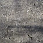
After about 200 m, a detour to the right goes down along some steep stairs and leads to the In Vall site, where the great R4 – one of the most interesting rocks of the area – can be observed. On its surface there are more than 700 figures and some subjects definitely peculiar to Paspardo. Among these, it is worth mentioning the three large warriors armed with “ox leather” shields (end of the 6th century BCE), which have similar examples also in the nearby area of Dos Sottolaiolo and Vite-‘Al de Fuos. Another interesting feature of the same rock is the high frequency of expanded-bladed axes, dating back to the Late Iron Age, which is another typical theme in several sites in Paspardo. Among the other petroglyphs, it is possible to see also a spiral and some praying figures (scarce in Paspardo), constituting the main subjects of R5 – in this case, in superimposition with several shovels.
Trail details
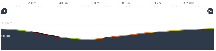
LENGTH: 2 Km (roundtrip)
ALTITUDE: Max 970 – Min 890
DIFFERENCE IN ALTITUDE: 80 m
KIND OF PATH: Unpaved hiking trail and paved road
DIFFICULTY: Easy
For the link to the trail, click here
Plas-Capitello dei Due Pini
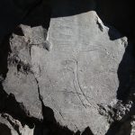 Certainly, one of the best-known sites in Paspardo is the area of Plas, especially for its Copper Age composition on stone wall (R1), called the “Rock of the Five Daggers” (or also “Capitello dei Due Pini”, meaning “Chapel of the Two Pines”).
The rock was discovered by Emmanuel Anati in 1957 and would later become the logo of the “Centro Camuno di Studi Preistorici” (CCSP), in 1964. Next to this rock there is the so-called “Rock of the Sun” (R2), a rock wall marked by Copper Age carvings, more scattered and harder to observe in comparison to R1. The Copper Age (3rd millennium BC) dating of the complex is unquestionably proved by the presence of triangular-bladed daggers with half–circle pommel (the so-called Remedello type), already well-known because of some examples found in many graves in the necropolis of Remedello Sotto (Brescia), dating back to 2,800-2,400 BCE. Both surfaces are marked by the graphic concepts shared by the statue-stelae that were discovered up to now in sites such as Ossimo, Borno, and Cemmo. This engraving repertoire includes the radiant sun, weapon compositions (daggers and halberds), rows of anthropomorphic figures with open arms, and animals. Among the latter, a special role must have been played by the male deer, whose antlers are often associated with the solar disc and whose use would last all along the Iron Age.
A few other nearby rocks — apart from a small bedrock carved with schematic praying figures, constituting the first example of rock art to be mentioned at Plas in the early ’50s by Piero Leonardi — show petroglyphs that are likely only from the Historic Age.
Trail details
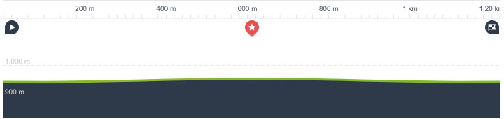
LENGTH: 1,2 km (roundtrip)
ALTITUDE: Max 980 – Min 970
DIFFERENCE IN ALTITUDE: 10 m
KIND OF PATH: Hiking trail
DIFFICULTY: Easy
For the link to the trail, click here
Vite-‘Al de Plaha
 The site of ‘Al de Plaha constitutes a little part of the large rock art area (including more than 100 rocks) of Vite-Deria, below the village of Paspardo. Several bedrocks, which were discovered only in recent times during the annual archaeological campaigns and are still under study, are placed along the historic path that goes directly down to the bottom of the valley (in local dialect, “Biàl do le Scale“, lit. “Downstairs way”). The site, which can be entered from a small clearing occupied by a little chapel, includes about twenty carved rocks, half of which can be observed on the visiting route.
The first rock along the route (R6), rising near the cobbled access way, is characterized by “topographic” compositions, likely dating back to the most ancient phases (Late Neolithic/Early Copper Age). The path goes on to the left and reaches R11, decorated with a beautiful sequence of warriors armed with spears and “ox leather” shields (Late Iron Age). A few meters further R13 rises, once again carved with a large “topographic” composition formed by doubled-rectangle elements, grids, pecked circles and surrounded by a perimeter line (Copper Age). Going back to the main route, the path heads South-West, leading to R7, an extraordinary surface engraved with Medieval figures (a keyhole and two keys, associated with a date referring to the end of the 15th century), linked to prehistoric elements such as a horseman, an expanded-bladed axe, a footprint (quite rare in Paspardo) and some warriors.